
Planning to climb Mount Kilimanjaro? The first tool you need is a reliable Mt Kilimanjaro map.
Whether you are a first-time climber or an experienced trekker, understanding the mountain’s routes, campsites, and terrain before you set foot on the trail makes an enormous difference. A good map does not just show you where to go — it helps you prepare mentally, physically, and strategically for one of the world’s most iconic climbs.
Let’s break it all down for you.
Mount Kilimanjaro sits prominently in the Kilimanjaro Region of Tanzania, Africa — and it is impossible to miss on any map of the continent.
Here are the essential facts every climber should know:
| Detail | Information |
|---|---|
| Location | Handeni, Tanga, Tanzania, Africa |
| Geographical Coordinates | 3.0674° S, 37.3556° E |
| Exact Latitude / Longitude | 3° 4′ 35″ S, 37° 21′ 15″ E |
| Height | 5,895 metres above sea level |
| Prominence | 5,885 metres above surrounding area |
| Highest Point | Kibo-Uhuru Peak |
| Type of Mountain | Volcanic |
| UTM Position | 317082 E 9659816 N, Zone 37 |
| Country | Tanzania |
| Mountain Range | Eastern Rift Mountains |
| First Successful Climb | October 1889 — Ludwig Purtscheller and Hans Meyer |
Kilimanjaro is known by different names around the world:
Locally, it is simply and proudly known as Mount Kilimanjaro — the Roof of Africa.
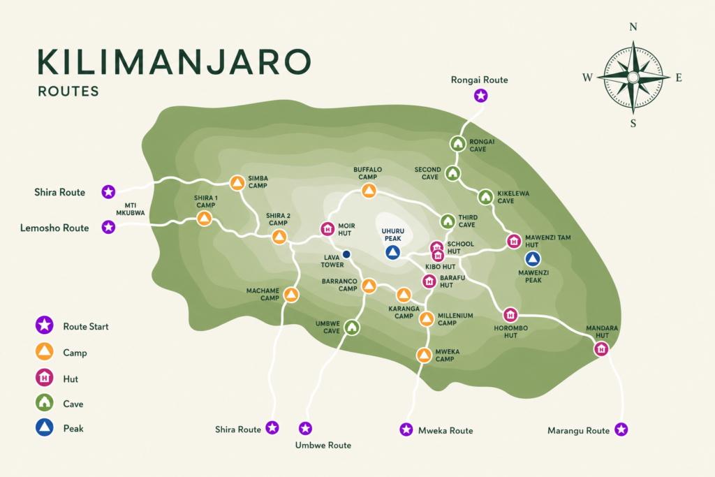
One of the most important decisions any climber makes is choosing the right route. The Mt Kilimanjaro map outlines several distinct trails, each offering a different experience in terms of scenery, difficulty, duration, and acclimatisation.
Here is an overview of the four most popular routes:
Often called the Whiskey Route, Machame is one of the most popular paths up Kilimanjaro — and for good reason.
For those seeking a quieter, more remote experience, the Rongai Route is an excellent choice.
Widely considered one of the most scenic routes on the mountain, Lemosho is a favourite among experienced climbers.
The Northern Circuit is the longest and most comprehensive route on Kilimanjaro — and arguably the most rewarding.
Each route on the Mt Kilimanjaro map has its own series of campsites, each sitting at a different elevation and offering a unique perspective of the mountain. Here is a full breakdown:
| Route | Starting Point | Campsites | Ending Point |
|---|---|---|---|
| Lemosho | Londorossi (2,100m) | Mti Mkubwa (2,820m), Shira 1 (3,500m), Shira 2 (3,850m), Barranco (3,900m), Karanga (3,960m), Barafu Base (4,670m) | Mweka Gate (1,640m) |
| Machame | Machame Gate (2,100m) | Machame (2,820m), Shira 2 (3,850m), Barranco (3,900m), Karanga (3,960m), Barafu Base (4,670m) | Mweka Gate (1,640m) |
| Rongai | Nalemuru Gate (2,020m) | Simba (2,625m), Second Cave (3,480m), Kikilewa (3,630m), Mawenzi Tarn (4,310m), Kibo (4,700m) | Mweka Gate (1,640m) |
| Northern Circuit | Londorossi (2,100m) | Mti Mkubwa (2,820m), Shira 1 (3,500m), Shira 2 (3,850m), Moir Hut (4,150m), Buffalo (4,020m), Third Cave (3,870m), School Hut (4,750m) | Mweka Gate (1,640m) |
Many climbers make the mistake of assuming that hiring an experienced guide is enough to guarantee reaching the summit. In reality, every route presents its own unique challenges — and thorough map knowledge is just as important as physical fitness.
Studying the Mt Kilimanjaro map carefully before your climb helps you in four key ways:
Awareness — You know exactly what to expect at each stage of the climb, with no unpleasant surprises along the way.
Preparation — A clear understanding of the terrain allows you to prepare both mentally and physically for what lies ahead.
Strategising — Each route has different camp stops with its own pros and cons. Analysing them helps you optimise your climb for success.
Informed Decision Making — Your route choice should factor in your time in Tanzania, previous climbing experience, current fitness level, and the prevailing weather conditions during your visit.
The static Mt Kilimanjaro map provides a focused, detailed overview of the mountain itself. It highlights:
It is the ideal planning tool for visualising your ascent and descent before you leave home.
The dynamic map zooms out to show Mount Kilimanjaro’s position within Africa — giving you a broader geographical picture. It includes:
This map is especially useful for travellers combining a Kilimanjaro climb with a wider Tanzania safari itinerary.
The Mt Kilimanjaro map is more than just a navigation tool — it is your foundation for a safe, well-planned, and successful summit attempt. From choosing the right route to understanding each campsite and acclimatisation stage, the map keeps you informed and prepared every step of the way.
Feeling overwhelmed by the route options? Our expert team at African Scenic Safaris is here to help. We will guide you through every detail of your climb and match you with the perfect Kilimanjaro climbing package for your goals, fitness level, and timeline.
Get in touch today and take your first step toward the Roof of Africa.